Planning Panels Victoria releases Panel Report on Sunbury Rings Cultural Landscape
From August to October 2017, the National Trust attended a Planning Panel hearing to advocate for the protection of the Sunbury Rings Cultural Landscape, classified by the Trust in June 2015. The landscape, in the Jacksons Creek valley, includes a number of highly significant Aboriginal and non-Aboriginal heritage places, including rare Aboriginal earth rings, which form a cultural landscape that has significant historical, aesthetic, and scientific values. The classification was developed in consultation with the Traditional Owners, the Wurundjeri Tribe Land and Compensation Cultural Heritage Council, for whom this is a place of ongoing cultural and spiritual significance.
The Trust’s statement of significance states:
Sunbury Rings Cultural Landscape is historically significant because of its role as a key place of interaction between people and the land over thousands of years. Indigenous land use is preserved in the landscape as is some of the oldest pastoral use of the land by settlers at Emu Bottom. The landscape testifies to the changes that have taken place in Victoria since settlement. Read as a whole the landscape presents a clear historical narrative of the history of Aboriginal land use and European settlement of the greater Melbourne region.
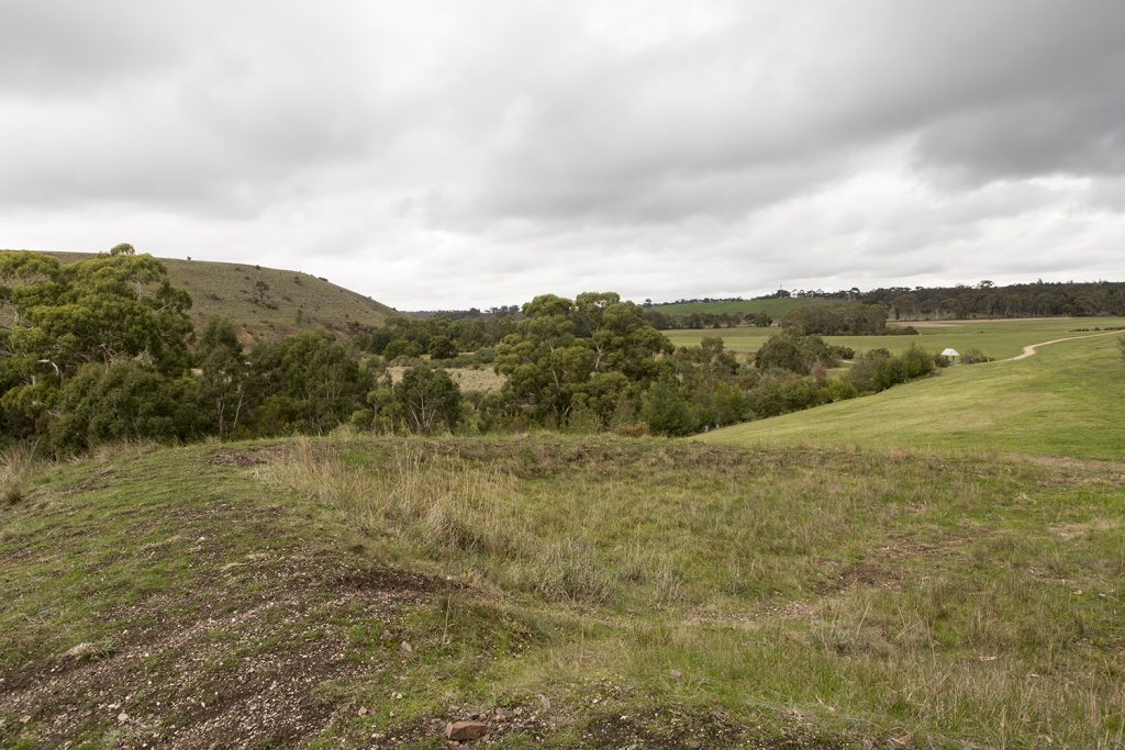
The Sunbury Rings are three of eight such earth rings in Victoria (two others are also located in the Sunbury area and other examples are less intact) making them extremely rare. The landscape of Jacksons Creek contributed to the use of the land by Aboriginal people. The alluvial flats and basalt plains made it an important source of food as well as providing water. The Rings are best understood as being part of the broader landscape rather than individual or isolated elements. The view lines and space around them play a part in understanding their context and use.
Some of the assets that made Jacksons Creek so valuable to the Traditional Owners of the area also made it valuable to the European settlers who arrived on the Enterprize in 1835. George Evans and William Jackson were the first settlers to find the Sunbury area and Jacksons Creek particularly appealing. Evans’ homestead, Emu Bottom, built in 1836 is considered to be one of the oldest homestead in Victoria and Jacksons squat later became the site of Rupertswood. The movement of the Clarke family into Sunbury in 1850 had a major impact on the landscape and the growth of the region. Clarke’s huge pastoral holdings included Jacksons Creek to the north of Sunbury and the Clarke family had significant impact on the use of the valley.
The landscape is aesthetically significant for its landscape character and as a rare example of an 1840s landscape nestled within an increasingly suburban context. The landscape has long been recognised as an exceptional aesthetic setting that drew people from Melbourne and the coast into inland Victoria, and features in 19th Century landscape paintings. The ridgelines and views of the valley are particularly important in maintaining this aesthetic value.
The landscape is of archaeological significance because of the presence of early settlement sites and established archaeological deposits. Canon Gully is registered in the Heritage Inventory for its established archaeological value and evidence of the volunteer militia camps of the 1860s but there are also other sites in the landscape that have potential to be archaeologically significant to both Aboriginal cultural history and post-contact history.
Lancefield Road and Sunbury South Precinct Structure Plans (Hume Planning Scheme Amendments C207 and C208)
The hearing, before a panel of four members of Planning Panels Victoria chaired by Trevor McCullough, was convened to consider two Precinct Structure Plans for prepared by the Victorian Planning Authority to facilitate new subdivisions and associated infrastructure in the Sunbury area, with the Sunbury Rings Cultural Landscape located in the Lancefield Road precinct. The Panel considered submissions from 93 different parties, including a number of community groups and individuals concerned about the natural and cultural heritage values of the Jacksons Creek Valley. The map below identifies the Sunbury Rings Cultural Landscape identified by the National Trust, as well as the individual heritage sites within the landscape.
Protection for Sunbury Rings Cultural Landscape
In response to numerous submissions regarding the significance of the complex cultural landscape in Jacksons Creek Valley, including a submission by the National Trust in support of our classification for the Sunbury Rings Cultural Landscape, the Panel Report contains a lengthy discussion about the need to protect the landscape in the context of future development, and looks at various statutory tools to achieve this, including the Significant Landscape Overlay. The Panel agreed with the submissions of the National Trust, Council and individual submitters that “the cultural heritage and associated landscape in this location should not been seen simply as a number of individually significant sites.” The Panel also agreed with the Trust’s argument that “there is a need for greater recognition of the broader heritage and associated landscape values of the Jacksons Creek valley, rather than just the individual elements.” The Panel also found that the PSP alone would not “provide adequate long-term protection for these broader cultural heritage values”, making a recommendation that “The VPA or Council should consider the future introduction of further planning scheme protection for the Sunbury Rings Cultural Landscape as identified by the National Trust in consultation with the National Trust, Wurundjeri Tribe Land and Compensation Cultural Heritage Council and the community.” With cultural landscapes increasingly the subject of academic and professional discussion, the Sunbury Rings Cultural Landscape offers a useful case study for achieving protection for places with complex heritage and environmental values which individually may be protected by separate pieces of legislation, but which may not be recognised or managed as a whole landscape.
Northern Crossing of Jacksons Creek
The key concern of the National Trust is a proposed crossing of Jacksons Creek, which would effectively bisect the Sunbury Rings Cultural Landscape, and have a significant impact on views along the valley. Traffic evidence provided at the Planning Panel indicated that this proposed crossing was not a priority in comparison with the proposed southern creek crossing, however it was not possible for experts and parties to the hearing to undertake a detailed visual impact assessment, as no detailed design has been undertaken. The National Trust argued that the strategic justification for a future crossing therefore did not warrant the significant impacts that such a crossing would have on the valley, and that it should be removed from the PSP. In our submission to the Panel, the Trust argued that there was not enough information to assess the visual impact of the bridge; yet if the alignment is included in the PSP, it may be seen to be a “fait accompli”. However the Panel found that the visual impacts of the bridge design could only be properly assessed in the context of the environs and landscape that exists when construction is imminent. In their Panel Report, the Panel took a middle ground, finding that the proposed alignment of the crossing should be retained in the PSP, but recommending the confirmation of the strategic justification of the crossing closer to the time of construction (which may not take place for decades). The Panel also recommended that detailed visual, environmental, and heritage impact assessments should be conducted on a detailed bridge design closer to the time of its construction. The Trust will continue to advocate for the crossing alignment to be abandoned, or if it goes ahead, that a sensitive elevated design is developed to respond to the heritage context of the valley.
Subdivision adjacent to Racecourse Road
In the National Trust’s original submission to the Precinct Structure Plan, we raised concerns regarding the impact of a proposed subdivision adjacent to Racecourse Road. As a result of concerns raised by the Trust, as well as community members and Hume Council, a revised subdivision plan was submitted prior to the hearing, which reduced the size of the subdivision, and increased lot sizes, ensuring that development is contained on the hillside next to Racecourse Road, and does not encroach on the more visually sensitive valley floor. This approach was supported by experts at the hearing, and on balance, the National Trust found that the revised subdivision plan was acceptable. The Trust also provided detailed feedback on proposed design controls, and supported the application of a Design and Development Overlay to ensure that development within the subdivision is responsive to the heritage of the valley.
What next?
The Victorian Planning Authority will now finalise the Structure Plan for approval, which will be submitted to the Minister for Planning in mid-2018. The Trust also looks forward to further discussions with the VPA, the Wurundjeri, and other stakeholders, about strengthening protections for the Jacksons Creek Valley landscape.
+ There are no comments
Add yours